interkriti®
YOUR GATEWAY TO CRETE
HOME
CRETE FACTS
NAVIGATE
EXPLORE

Agia Galini
Triopetra
Kissamos
Chryssi Isl.
Agia Marina
Balos
Gavdos isl.
Georgioupolis
SAMARIA
IDA Mtn
Palaiochora
Agia Roumeli
Sfakaki
Bali
Kalamaki
Matala
Lassithi
Plateau Lendas
Tsoutsouros
Vianos
Myrtos
Sfakia
Plakias
Ierapetra
Makrygialos
ZAKROS
Vai
Sitia
Agios Nikolaos
Elounda
MALIA
Hersonissos
Gouves
Chania
Rethymnon
Heraklion
GORTYN
FESTOS
KNOSSOS
|
|
Crete
List Grid Map
Found
440
- Showing :
141 - 160
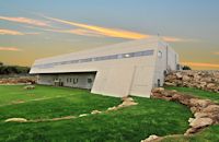 Mylopotamos, Rethymno The " Museum of ancient Eleutherna - Homer in Crete" , was created to accommodate the results of the excavations carried out for thirty years in the ancient city of Eleutherna (Eleftherna GR: Ελεύθερνα). It is a modern building approximately 1,800 sq.m. which together with the surrounding area occupies 3 acres and remotely resembles ark that emerges from the earth, gazing Ida (Psiloritis). 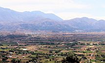 Lassithi, Dikti Mountains The Lassithi Plateau (GR: Οροπέδιο Λασιθίου, Oropedio Lasithiou), is a high endorheic plateau, located in eastern Crete, Greece on the mountain range of Dikti at an average altitude of 840 m, and in a distance of around 55km from Heraklion and 50km from Agios Nikolaos. The plateau is elliptical in shape with an E-W axis of 11km and the N-S of 7km. The plateau of Lassithi is renowned for its exceptional agricultural produce, the thousands (almost 15000) windmills that used to be there in the past, its significant historical role and for the unique cave of Psychro also known as "Diktaion Andron". Image Library
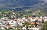
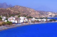 Ierapetra, Lassithi Myrtos (GR: Μύρτος) is situated 15km to the west of Ierapetra, at the estuaries of the river Sarantapihos, in a valley with olive and orange trees. It is a beautiful village built by the sea, with a beach street lined with taverns and cafe bars. In a short distance from Myrtos on a low hill lies the archaeological site of "Pyrgos" with the ruins of a villa from the post minoan period and a little further at "Fournou Koryfi" lie the ruins of a proto minoan settlement. Myrtos features a small archaeological museum with exhibits mostly from the area, an initiative of a local teacher. Myrtos is a popular tourist destination, with nice small hotels, picturesque taverns and kafeneions, a lovely sandy beach and hospitable people. Image Library
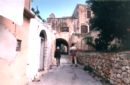
 Agios Nikolaos, Lassithi The Folk Art Museum of Aghios Nikolaos, in collaboration with the "Cultural Society of Eastern Crete", founded in 1978. All the original and important material was generously offered by the Touring Club of Aghios Nikolaos. Since then more objects have been added to the collection. A visit to the Folk Art Museum will help you to become familiar with the sort of work and activities the people of this area had in the old days. The Museum houses a rich and beautiful collection of hundreds of genuine samples of Cretan popular art and mainly hand woven and embroidered pieces, some of which are unique. 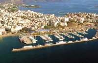 Agios Nikolaos, Lassithi Well protected Marina by all weather condition, build to European standards and capable to accommodating up to 255 boats all year round. The Marina of Aghios Nikolaos is located in the heart of the town, provides all the necessary facilities for a pleasant short or long stay for yacht passengers and a safe environment for the boats. Facilities: Water/Electricity:Each berth has access to a service box where fresh water and 220 / 380 volt electricity available. 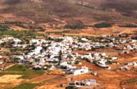 Sitia, East Lassithi The village of Handras (or Chandras (GR: Χανδράς) is in the Municipality of Lefki at the Armeni-Handras plateau and 27 km from the town of Sitia. First recorded in a venetian census in 1583 as Candra and Chandra with a population of 399 like today. Ancient Minoan sites were found at the Plakalonia area as well as at the Gras and Katrani places. There is a peak sanctuary at the hill of Xykefalo between Handras and Kasteliona at an altitude of 705 m. In spite of its looting a lot of ancient objects were found. The cave of Panagia Gouda is at the Handra region. This region includes the communities of Voila, Agios Panteleimonas and Pano Panteli. At Pano Panteli there is an old church the Metamorfosis in which there is an inscription that says: Petro Abramo was here in 1486. 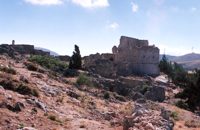 Sitia, East Lassithi The settlement of Voila (GR: Βόϊλα) is 1km away from the village of Handras. It is a medieval deserted village protected by the Greek Archaeological Authorities. Passing through the village's alleys you can still see the ruins of old houses and their rooms, their venetian features and through this sacred silence of the place you have the impression that you hear the Byzantine king, the medieval knight or the Turk fighter gallop away. The name of the village probably comes from the Byzantine word VOILAS or VOLIAS meaning the nobleman, the land owner. In a census carried out by Kastrofilaka in 1583, the village of Voila had a population of 301. Many elements show that the village belonged to the venetian family of Zenos which during the Turkish occupation adopted the Ottoman religion and was renamed.The tradition says that he was the owner of a Castle in Voila which has an external inscription with the date 1153 equal to 1742 of the Christian diary. At the south of the castle there is a ruined church known as the church of Ginali. Other attraction at the area is the old painted church of St. George dated back to the 15th century. From the inscription it is obvious that there is a family tomb of Salamons. The Solomons of the island of Zakynthos where our national poet Dionisios Solomos comes from, are believed to having been descended from the Salamons of Sitia. At the top of the hill overlooking the village there is a fortress dated back to the Venetian occupation of the island of Crete. Image Library
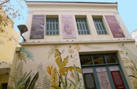 Iraklion city, Heraklion In the heart of the city center of Heraklion, opposite the church of Agios Minas, is the Museum of traditional music, instruments, research & documentation with the characteristic title 'Thirathen'. The Museum was founded in 2012 with its headquarters in the historic village of Krousonas, in the Municipality of Malevizi. In December 2023, it opened its doors to the public, in its new space in the center of the city of Heraklion. 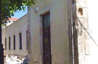 Ierapetra town, South Lassithi The museum was founded at the end of the 19th century, during the Turkish occupation of Crete and was housed in several buildings in the past. Today it is housed in the building of the Commercial Ottoman School, which is protected by a preservation order. The collection includes findings from the broader area and from the Minoan to the Roman period. Among the items are painted sarcophagi, lamps, vases, figurines, relief plaques. One of the most important exhibits of the museum is the Clay sarcophagus dated to 1450-1400 B.C.
Image Library
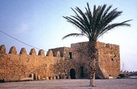 Ierapetra town, South Lassithi The fort, built by the Venetians and Known to Ierapetrans as the "Kalés" (GR: Καλές), has been erected on the top of the southernmost mole of the ancient harbour. It is one of those monuments of the past which, because of its solid construction and the fact that it was still garrisoned until the latest years of the last century, still exists today to serve as a reminder of some of the nation's most difficult times.
Image Library
 Gonia, Rethymno The Municipality of Nikiforos Fokas is located in the north of Rethymnon Prefecture. The area is known for its outstanding natural beauty and its historical tradition and architecture. All of the municipality's settlements are steeped in history and contain fine examples of architecture, featuring stone buildings with vaulted entrances (known as "diavatika") and magnificent thresholds. The municipality's jurisdiction extends over the fourteen former community wards of Agios Konstantinos, Ano Valsamonero, Atsipopoulo, Gerani, Gonia (Athanatos), Zouridi, Kalonyktis, Kato Valsamonero, Malaki, Mountros, Prines, Roustika, Saitoures and Frantzeskiana Metochia, which comprise a total of 21 villages. 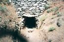 Amari, Rethymnon The village of Apodoulou is located 55 km from Rethimno at an altitude of 450m. Remains of an extensive centre of the Old Palace period (1950-1700 B.C.) have been uncovered.at the site called Gournes, near the village of Apodoulou, at the west foot of Psiloreitis. The site dominates the Amari valley and controls the main route to the Messara plain. Excavations have brought to light three building complexes while tholos tombs of the Postpalatial period (1380-1200 B.C.) have also been located in the adjacent area. The first excavations on the site were carried out by S. Marinatos in the 1930's. During World War II it was excavated by the German Archaeological Institute, under the direction of E. Kirsten. Since 1985, systematic excavations have been carried out by the Greek Ministry of Culture in collaboration with the University of Naples. The most important monuments on the site are: Building A. It lies on the east side of the hill, to the south of the massive retaining wall. It had two storeys, as is indicated by the two preserved steps of a staircase. Decades of pithoi and other vases found on the ground floor suggest that it was used for storage. The house was destroyed by fire which followed an earthquake. Building B, located to the north of the retaining wall. It is a complex of rooms which originally communicated with Building A. Building C. It lies to the east of house A and belongs to a later phase of the settlement. Tholos tomb at Sopatakia. Tholos tomb with dromos, lying to the east of the road that leads from Apodoulou to Nithavris. The dromos is 7 m. long and the chamber has a diameter of 3.10 m. Three larnakes were found inside the burial chamber. Dated to 1380-1200 B.C. Source: The Hellenic Ministry of Culture 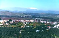 Pediada, Iraklion Kastelli (GR: Καστέλλι) is a small town in the countryside of the province of Pediada. It has over 2000 inhabitants and provides all the modern facilities and public services its residents and/or visitors may need. Many events are organized through the year by the municipality, the school and the cultural centre. In August a special festival, known as the Feast of Xenitemenou (ex-patriot feast) includes concerts, folklore, exhibitions and theatre plays.
 Kenouriou, South Iraklion Zaros (Greek: Ζαρός), at an altitude of 340 metres, is a town with a lake and gorge nearby. It has a couple of hotels and it is 44 km from Heraklion at the southern foothills of Mountain Psiloritis. The population of 3,400, produce olive oil, sultanas, vegetables and spring water. There are a couple of fish farms that serve both trout and salmon. In Zaros, there are cafes near Lake Votomos, as well as a tavern that serves fresh trout called I Limni (The Lake). Close by is Rouvas Gorge, which is part of the Psiloritis mountain range and is on the hiking route known as the E4 European Walking Path. Nearby Zaros are traditional water mills which have been working since the 16th century, as well as archaeological sites and monasteries. Zaros is also famous for its water "ZAROS" bottled by a company called Votomos SA. 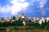 Sitia, East Lassithi Piskokéfalo (GR: Πισκοκέφαλο), a principal village located 3 km south of Sitia. Piskokefalo is the birth place of the great poet Vincentzos Kornaros, who wrote the masterpiece of Medieval poetry, "Erotokritos". The village is mentioned at the census of 1577 by Fr. Barozzi, and became the seat of the commanding officer, after the destruction of the town of Sitia in 1538 by the pirate Chairentin Barbarossa. Nowadays Piskokefalo is a beautiful village where a stop is worthwhile. The visitor can see the house of Kornaros, enjoy a coffee or a meal at the village's square, visit the spring at Zou, the old water mill, the church of "Agia Anna" and the small chapel of "Panagia Trapezounta". 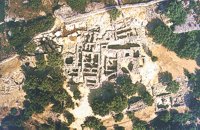 Archanes Excavations at Phourni have brought to light 26 buildings, most of which had funerary use. The cemetery was used from 2400 B.C. until 1200 B.C. and each complex had more than one architectural phase. Most of the funerary buildings were used for many decades and contain successive burials. Excavations were begun in 1964 by Efi and John Sakellarakis and have been continued until today (1995) with short interruptions. Most of the buildings are preserved in good condition. 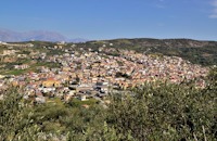 Archanes, Iraklion A small traditional town (~4000 people) 15 km south of Iraklion on the foot of the sacred mountain Yiouhtas. Renowned for its excellent wine (from the varieties: vilana, kotsifali and madilari) and the archaeolocical sites and caves. In 1912, Xanthoudides noted the importance of Archanes, but Sir Arthur Evans was the first to characterize the site as palatial, declaring that Archanes was likely a Summer Palace for the Knossos kings. Spyridon Marinatos and N. Platon excavated minor areas in the region, but nothing supported Evans' theory. In 1964, J. Sakellarakis dug trial trenches at the Tourkoyeitonia site and uncovered the first evidence of a palace site. Since 1966, Archanes has been excavated by the Greek Archaeaological Society under the supervision of John Sakellarakis and Efi Sapouna-Sakellarakis. The small town of Epano Archanes, one of the most famous places of the Cretan land, with its colorful courtyards, teaches culture, taste, tradition, colors, aromas and life itself. The silvery grays of the olive groves, the red, pink, salmon and tiled walls, the blue and green shutters, the colorful bougainvillea boldly climbing the walls of the houses, the manicured flower beds, but also the elaborate, colorful signs in coffee shops and grocery stores. All this makes Archanes the most colorful village of Crete, but also of Greece. The town is full of atmospheric neighborhoods with well-maintained houses, painted in cheerful colors. At each step the visitor learns more and more about it. That's why the locals have taken care of it: the Folklore Museum, the Archaeological Museum, the sculpture workshop, the Museum of Cretan History and Tradition just outside. Image Library
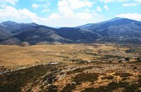 Psiloritis Mountain The plateau is located in the center of the Ida mountain range at an altitude of 1400 m. It can be accessed from various sides but the only asphalt road is from the town of Anogeia. It has a roughly triangular shape and is almost flat. Visitors can enjoy the wild landscape, take a walk to the entrance of Idaion cave or to the freedom fighter sculpture, made with boulders from the mountain. An other interesting attraction is the various Mitata scattered all over the area. Those are circular domed buildings made with stones and used by shepherds for accommodation and storage of cheese. There is also a tavern with traditional food. The area of Nida, in earlier times, before the systematic farming and logging damage the flora of Psiloritis, was covered by forests in which mythological and traditional tales put different events. Here Dimitra fell in love with the mortal Iasion. http://www.anogialand.gr 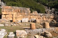 Ancient town in Selino, South Hania Located ~2.3km west of Sougia it was the religious centre of the cities in south-west Crete and the port of Elyros. It flourished during the Hellenistic and Roman periods. In 1957-58 Asklepieion was excavated by N. Platon. The most important monuments of the site are: The Temple of Asklepios, dated to the Hellenistic and Roman periods, Part of a Roman theatre, Rock-cut and built chamber tombs. There two byzantine chapels dedicated to Our Lady and Agios Kirikos The beach in the small cove has coarse pebbles and clear waters. Lissos (GR: Λισσός) nowadays is uninhabited and can be reached from Sougia only by foot (~1& 1/2 hours walk) or by boat (~20 minutes). 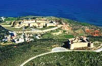 Aptera, Apokoronas, Hania Those are two Turkish castles that are built in the 19th century using material from the nearby archaeological site of Aptera. The lower castle is that of Itzedin (also known as Kalami fort) named in honour of the son of the Sultan of the time, by the commander of Crete, Reouf Pasha was used in the past as a prison.
|
||
|
| ||


C
O
N
T
E
N
T
S
O
N
T
E
N
T
S